
🗺️ India: Physical Features भारत: भौतिक स्वरूप
227 exam-ready facts · 227 MCQs
-
81
Citizens of Nepal do not require a passport or visa to enter India under special bilateral treaties.
The 1950 Indo-Nepal Treaty of Peace and Friendship allows free movement of citizens across the border.
Asked in SSC CGL 2017 (20 Aug, Shift 2)
Practice (1)
Q81Citizen of which neighbouring country does not require a passport or visa to enter India?
Show answer
Correct answer: C — Nepal
Answer: (C)
Under the 1950 treaty, Nepali citizens need no passport or visa to enter India. -
82
Sri Lanka is separated from India by a narrow channel of sea formed by the Palk Strait and the Gulf of Mannar.
Adam's Bridge (Ram Setu) is a chain of limestone shoals connecting Pamban Island in India to Mannar Island in Sri Lanka.
Asked in SSC CGL 2017 (20 Aug, Shift 3)
Practice (1)
Q82________ is separated from India by a narrow channel of sea formed by Palk Strait and the Gulf of Mannar.
Show answer
Correct answer: A — Sri Lanka
Answer: (A)
Sri Lanka is separated from India by the Palk Strait and the Gulf of Mannar. -
83
The total land mass of India has an area of approximately 3.28 million square kilometers.
India accounts for about 2.4 percent of the total world's land area.
Asked in SSC CGL 2017 (20 Aug, Shift 3)
Practice (1)
Q83The land mass of India has an area of ______ million square km.
Show answer
Correct answer: C — 3.28
Answer: (C)
India's total area is about 3.28 million sq km. -
84
The longitudes of the mainland of India extend between 68°7' E and 97°25' E.
This longitudinal extent of nearly 30 degrees causes a time lag of about two hours between Gujarat and Arunachal Pradesh.
Asked in SSC CGL 2017 (20 Aug, Shift 2)
Practice (1)
Q84The longitudes of main land of India extends between<br>__________.
Show answer
Correct answer: A — 68°7' E and 97°25' E
Answer: (A)
The Indian mainland lies between longitudes 68°7′ E and 97°25′ E. -
85
Weathering is the breaking up and disintegration of rocks on the Earth's surface by atmospheric agents.
Unlike erosion, weathering is an in-situ process that does not involve the removal of rock debris.
Asked in SSC CGL 2017 (21 Aug, Shift 1)
Practice (1)
Q85___________ is the breaking up of the rocks on the earth's surface.
Show answer
Correct answer: B — Weathering
Answer: (B)
Weathering is the breaking up of rocks at the Earth's surface. -
86
Lipu Lekh is a high-altitude mountain pass in Uttarakhand used by pilgrims for the Kailash-Mansarovar Yatra.
Lipu Lekh pass is situated near the trijunction of India, China, and Nepal borders.
Asked in SSC CGL 2018
Practice (1)
Q86Name the pass in Uttarakhand which is used by pilgrims to Kailash-Mansarovar Yatra.
Show answer
Correct answer: D — ['4', 'Lipu Lekh']
Answer: (D)
The correct option is (D). -
87
The latitudes of the mainland of India extend between 8°4' N and 37°6' N.
The southernmost point of the Indian mainland is Cape Comorin (Kanyakumari) in Tamil Nadu.
Asked in SSC CGL 2017 (21 Aug, Shift 3)
Practice (1)
Q87The latitudes of main land of India extends between<br>__________.
Show answer
Correct answer: A — 8°4' N and 37°6' N
Answer: (A)
The Indian mainland lies between latitudes 8°4′ N and 37°6′ N. -
88
Landslides are defined as the mass movement of rock, debris, or earth down a slope under the influence of gravity.
Heavy rainfall, earthquakes, and deforestation are primary triggers for catastrophic landslides.
Asked in SSC CGL 2017 (21 Aug, Shift 2)
Practice (1)
Q88___________ are defined as the mass movement of rock, debris or earth down a slope.
Show answer
Correct answer: D — Landslide
Answer: (D)
A landslide is the mass movement of rock, debris or earth down a slope. -
89
Glacial moraines are deposits of rocks, sand, and silt carried and dropped by glaciers.
Moraines can be classified into terminal, lateral, and medial types depending on their location relative to the glacier.
Asked in SSC CGL 2017 (21 Aug, Shift 2)
Practice (1)
Q89The material carried by the glacier such as rocks big and small, sand and silt gets deposited, which are called glacial ________.
Show answer
Correct answer: A — moraines
Answer: (A)
Glacial deposits of rocks, sand and silt are called moraines. -
90
Nanda Devi Peak is located in Uttarakhand and is the second-highest mountain in India.
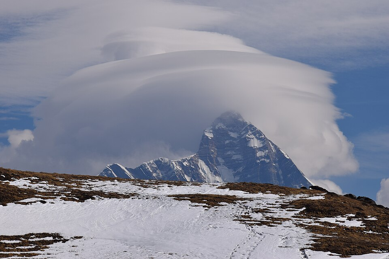
It is part of the Himalayan range and is surrounded by the Nanda Devi National Park.
Asked in SSC CGL 2018
Practice (1)
Q90The Nanda Devi Peak is located in___________.
Show answer
Correct answer: B — ['2', 'Uttarakhand']
Answer: (B)
The correct option is (B). -
91
Nathu La pass connects Sikkim with Tibet and was reopened for trade in 2006.
It is one of the three open trading border posts between China and India.
Asked in SSC CGL 2018
Practice (1)
Q91________ , which connects Sikkim with Tibet, was closed after the Chinese aggression<br>on India in 1962 but was reopened in 2006 as the governments of the two countries<br>decided to enhance their trade through land routes.
Show answer
Correct answer: B — ['2', 'Nathu La']
Answer: (B)
The correct option is (B). -
92
Banihal Pass is known as the gateway connecting Jammu and Srinagar.
It cuts across the Pir Panjal range in the Jammu and Kashmir union territory.
Asked in SSC CGL 2018
Practice (1)
Q92Which of the following passes is known as the gateway connecting Jammu and<br>Srinagar?
Show answer
Correct answer: B — ['2', 'Banihal Pass']
Answer: (B)
The correct option is (B). -
93
Rohtang Pass in Himachal Pradesh is a famous high-altitude tourist attraction.
It connects the Kullu valley with the Lahaul and Spiti valleys of Himachal Pradesh.
Asked in SSC CGL 2018
Practice (1)
Q93________ in Himachal Pradesh is a famous tourist attraction.
Show answer
Correct answer: A — ['1', 'Rohtang Pass']
Answer: (A)
The correct option is (A). -
94
Bum La Pass connects Tawang in Arunachal Pradesh with Lhasa in Tibet.
It is situated about 37 km away from Tawang at the Indo-China border.
Asked in SSC CGL 2018
Practice (1)
Q94Which of the following passes connects Tawang with Lhasa?
Show answer
Correct answer: C — ['3', 'Bum La Pass']
Answer: (C)
The correct option is (C). -
95
Zoji La is an important mountain pass providing a road link between Srinagar, Kargil, and Leh.
It is located on the Indian National Highway 1 between Srinagar and Leh in the Zaskar range.
Asked in SSC CGL 2018
Practice (1)
Q95________ is an important road link between Srinagar on one side and Kargil and Leh<br>on the other side.
Show answer
Correct answer: C — ['3', 'Zoji La']
Answer: (C)
The correct option is (C). -
96
Muling La pass connects Uttarakhand and Tibet and lies north of Gangotri.
It is situated at a high altitude in the Greater Himalayas.
Asked in SSC CGL 2018
Practice (1)
Q96______ दराŊ उȅराखंड और ितɬत को जोड़ता है और गंगोũी के उȅर मŐ İ̾ थत है।
Show answer
Correct answer: C — ['3', 'मुिलंग ला']
Answer: (C)
The correct option is (C). -
97
Varkala, Chowara, Chavakkad and Nattika are popular coastal beaches in the state of Kerala.
Kerala is well-known for its long tropical coastline along the Arabian Sea.
Asked in SSC CGL 2018
Practice (1)
Q97Varkala, Chowara, Chavakkad and Nattika are beaches in the state of _____.
Show answer
Correct answer: A — ['1', 'Kerala']
Answer: (A)
The correct option is (A). -
98
The Andaman and Nicobar Islands are a major Indian island group located in the Bay of Bengal.
Port Blair serves as the capital of this Union Territory.
Asked in SSC CGL 2018
Practice (1)
Q98Which of the following Indian islands lies in the Bay of Bengal?
Show answer
Correct answer: C — ['3', 'Andaman and Nicobar']
Answer: (C)
The correct option is (C). -
99
A canyon is a deep, narrow valley with steep sides carved by prolonged river erosion.
The Grand Canyon in the United States is one of the most famous examples globally.
Asked in SSC CGL 2018
Practice (1)
Q99What is the geographic name given to a deep and narrow valley consisting of steep<br>sides created by weathering and erosion by rivers, wind, rain and tectonic activity?
Show answer
Correct answer: B — ['2', 'Canyon']
Answer: (B)
The correct option is (B). -
100
Diphu Pass is a tri-junction border point between India, Myanmar, and China on the McMahon Line.
It is strategically located in the eastern section of the Himalayas.
Asked in SSC CGL 2018
Practice (1)
Q100The 'Diphu Pass' which is the tri-junction between India, Myanmar and China is on this<br>Border Line?
Show answer
Correct answer: A — ['1', 'McMahon Line']
Answer: (A)
The correct option is (A).