
🗺️ India: Physical Features भारत: भौतिक स्वरूप
227 exam-ready facts · 227 MCQs
-
141
Pushkar is a holy town located in the Ajmer district of the Indian state of Rajasthan.
It is famous for its annual camel fair held during Kartik Purnima.
Asked in SSC CGL 2021 (23 Aug, Shift 2)
Practice (1)
Q141Which of the following cities is closest to the location of Pushkar Fair?
Show answer
Correct answer: A — Ajmer
Answer: (A)
Pushkar is in Ajmer district of Rajasthan. -
142
Anai Mudi is the highest peak of the Western Ghats and the Deccan Plateau, located in Kerala.
It has an elevation of 2,695 meters above sea level.
Asked in SSC CGL 2021 (23 Aug, Shift 2)
Practice (1)
Q142Identify the state in which you will find the highest peak of the Deccan Plateau, Anai Mudi.
Show answer
Correct answer: D — Kerala
Answer: (D)
Anai Mudi is in Kerala. -
143
Haryali is a watershed development scheme, whereas Kund, Tanka, and Johad are traditional water harvesting structures.
Traditional structures are widely used in arid regions like Rajasthan to store rainwater.
Asked in SSC CGL 2021 (23 Aug, Shift 3)
Practice (1)
Q143Which of the following is NOT a traditional water storage structure?
Show answer
Correct answer: C — Haryali
Answer: (C)
Kund, Tanka and Johad are traditional water storage structures; Haryali is a watershed scheme.
Hence, the answer is option (C). -
144
The 82°30'E longitude passing through Mirzapur in Uttar Pradesh is chosen as the Standard Meridian of India.
Indian Standard Time (IST) is ahead of Greenwich Mean Time (GMT) by 5 hours and 30 minutes.
Asked in SSC CGL 2021 (23 Aug, Shift 2)
Practice (1)
Q144Which longitude has been selected as the Standard Meridian of India?
Show answer
Correct answer: A — 82°30'E
Answer: (A)
82°30′E longitude (through Mirzapur) is the Standard Meridian of India. -
145
Gondwanaland was an ancient supercontinent that included India, Australia, South America, Africa, and Antarctica, but not North America.
North America was part of the northern supercontinent known as Laurasia.
Asked in SSC CGL 2021 (23 Aug, Shift 3)
Practice (1)
Q145Which of the following was NOT a part of Gondwanaland?
Show answer
Correct answer: D — North America
Answer: (D)
Gondwanaland included South America, Africa, India, Australia and Antarctica, not North America.
Hence, the answer is option (D). -
146
Dhaulagiri, one of the world's highest mountains in the Himalayas, literally translates to 'White Mountain'.
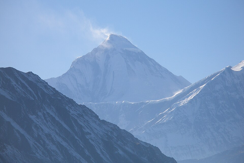
Its name is derived from the Sanskrit words dhawala (white) and giri (mountain).
Asked in SSC CGL 2021
Practice (1)
Q146Which of the following is also known as the ‘White Mountain’?
Show answer
Correct answer: C — Dhaulagiri I
Answer: (C)
Dhaulagiri means "white mountain" (dhawala = white, giri = mountain). -
147
An aquifer is a saturated underground geological formation or unit capable of yielding significant quantities of water to wells.
Aquifers are crucial sources of freshwater for drinking and agricultural irrigation worldwide.
Asked in SSC CGL 2021 (24 Aug, Shift 2)
Practice (1)
Q147A saturated geological unit which can yield water to the wells at a sufficient rate to support a well is called ______.
Show answer
Correct answer: D — aquifer
Answer: (D)
An aquifer is a saturated rock unit that yields water to wells.
Hence, the answer is option (D). -
148
The Aravalli range in India is among the oldest fold mountain systems globally, while Mt. Kilimanjaro is a volcanic mountain in Africa.
Mountain ranges are formed when multiple mountain systems are arranged in a continuous line.
Asked in SSC CGL 2021
Practice (1)
Q148Which of the following statements is/are correct regarding the mountains?<br>I- Mountains may be arranged in a line known as range.<br>II-The Aravali range in India is one of the oldest fold mountain systems in the world. III- Mt. Kilimanjaro in South America is an example of Volcanic Mountain
Show answer
Correct answer: A — Only I and II
Answer: (A)
I and II are correct. Kilimanjaro is in Africa (Tanzania), not South America, so III is wrong. -
149
Deomali (1,672 m) in Koraput district is the highest mountain peak of Odisha.
It is located in the Eastern Ghats mountain range.
Asked in SSC CGL 2021
Practice (1)
Q149The Deomali is the highest mountain peak of ______.
Show answer
Correct answer: D — Odisha
Answer: (D)
Deomali (1,672 m) in Koraput is the highest peak of Odisha. -
150
Gorichen peak is a prominent mountain peak located in the state of Arunachal Pradesh.
It is a popular destination for mountaineering and trekking expeditions in the Himalayas.
Asked in SSC CGL 2021
Practice (1)
Q150In which of the following Indian states is the Gorichen peak located?
Show answer
Correct answer: B — Arunachal Pradesh
Answer: (B)
Gorichen peak is in Arunachal Pradesh. -
151
Netarhat, known as the 'Queen of Chotanagpur', is located in the state of Jharkhand.
It is a picturesque hill station known for its sunrise and sunset viewpoints.
Asked in SSC CGL 2021
Practice (1)
Q151In which of the following Indian states will you find the Netarhat Mountains, also called ‘Queen of Chotanagpur’?
Show answer
Correct answer: B — Jharkhand
Answer: (B)
Netarhat, the “Queen of Chotanagpur”, is in Jharkhand. -
152
The Dhauliganga river flows near the majestic Nanda Devi massif in Uttarakhand.
Nanda Devi is the second highest mountain peak in India.
Asked in SSC CGL 2021
Practice (1)
Q152Which of the following mountains is located near the river Dhauliganga?
Show answer
Correct answer: B — Nanda Devi
Answer: (B)
The Dhauliganga flows near the Nanda Devi massif in Uttarakhand (official SSC key). -
153
Mount Tiyi is situated in the Wokha district of the northeastern state of Nagaland.
It holds great mythological and cultural significance for the local Lotha tribe.
Asked in SSC CGL 2021
Practice (1)
Q153In which Indian state will you find Mount Tiyi?
Show answer
Correct answer: D — Nagaland
Answer: (D)
Mount Tiyi is in Wokha district, Nagaland. -
154
Kanchenjunga, the third highest mountain in the world, lies on the border between India and Nepal.
It is located in Sikkim on the Indian side and Taplejung district on the Nepalese side.
Asked in SSC CGL 2021
Practice (1)
Q154Which of the following is a mountain between India and Nepal?
Show answer
Correct answer: D — Kanchenjunga
Answer: (D)
Kanchenjunga lies on the India (Sikkim) - Nepal border; the others are in Nepal. -
155
Sheet erosion is considered the LEAST visible form of soil erosion.
It removes a thin, uniform layer of topsoil over a large area during heavy rains.
Asked in SSC CGL 2021
Practice (1)
Q155Which of the following is the LEAST visible form of land erosion?
Show answer
Correct answer: C — Sheet erosion
Answer: (C)
Sheet erosion removes a thin uniform layer and is the least visible form. -
156
The Annapurna mountain peak is located in the Nepal Himalayas region.
It is a massif in the Himalayas containing one peak over 8,000 metres.
Asked in SSC CGL 2021
Practice (1)
Q156The Annapurna peak belongs to which region of the Himalayas?
Show answer
Correct answer: A — Nepal
Answer: (A)
Annapurna is in the Nepal Himalaya. -
157
Reduction in vegetation cover increases soil erosion and landslide risks, making it an incorrect mitigation technique.
Plant roots help bind the soil and prevent slopes from collapsing.
Asked in SSC CGL 2021
Practice (1)
Q157Which of the following is NOT a broad mitigation technique of landslide?
Show answer
Correct answer: D — Reduction in the vegetation cover to arrest landslide
Answer: (D)
Reducing vegetation increases landslides, so it is not a mitigation technique. -
158
According to BIS specifications (IS 10500:2012), the acceptable pH value of drinking water in India is 6.5 to 8.5.
This range ensures water is neither too acidic nor too alkaline for consumption.
Asked in SSC CGL 2021
Practice (1)
Q158According to the Central Ground Water Board, BIS (IS_10500 and revised module IS 10500:2012) specifications in Uniform Drinking Water Quality Monitoring Protocol, what is the acceptable pH value of drinking water specification in India?
Show answer
Correct answer: C — 6.5 - 8.5
Answer: (C)
The BIS acceptable pH range is 6.5–8.5. -
159
The Peninsular Plateau of India is roughly triangular in shape with its base in the north.
It is bounded by the Aravallis, the Satpura range, the Western Ghats, and the Eastern Ghats.
Asked in SSC CGL 2022
Practice (1)
Q159The shape of peninsular plateau in India is ______.
Show answer
Correct answer: D — Triangular
Answer: (D)
The Peninsular Plateau is roughly triangular. -
160
The boundary line demarcating India and Pakistan is known as the Radcliffe Line.
It was drawn by Sir Cyril Radcliffe during the partition of India in 1947.
Asked in SSC CGL 2022
Practice (1)
Q160The border line which separate Indian and Pakistan is known as ______.
Show answer
Correct answer: C — Radcliffe line
Answer: (C)
The India–Pakistan border is the Radcliffe Line.