
🗺️ India: Physical Features भारत: भौतिक स्वरूप
227 exam-ready facts · 227 MCQs
-
1
India's area is about 3.287 million km² — about 2.4% of the world's land area; India is the world's 7th-largest country by area.
Practice (1)
Q1By area, India ranks in the world:
Show answer
Correct answer: A — Seventh
India is first in population but seventh in area. -
2
The Tropic of Cancer passes through 8 Indian states: Gujarat, Rajasthan, Madhya Pradesh, Chhattisgarh, Jharkhand, West Bengal, Tripura and Mizoram.
It does not pass through Odisha or Bihar — a common trap.
Practice (1)
Q2The Tropic of Cancer does NOT pass through:
Show answer
Correct answer: B — Odisha
The 8 states: Gujarat, Rajasthan, MP, Chhattisgarh, Jharkhand, WB, Tripura, Mizoram. -
3
Indian Standard Time (IST) is based on 82°30′ E longitude, which passes near Mirzapur (Uttar Pradesh); IST = UTC + 5:30.
Each 1° of longitude = 4 minutes of time.
Practice (1)
Q3Indian Standard Time is based on which longitude?
Show answer
Correct answer: C — 82°30′ E
It passes near Mirzapur; IST = UTC+5:30. -
4
Indira Point (Great Nicobar Island) is the southernmost point of India; the southernmost point of the mainland is Kanyakumari.
Practice (1)
Q4The southernmost point of India is:
Show answer
Correct answer: D — Indira Point
Kanyakumari is the southernmost point of the mainland. -
5
India's longest international land border is with Bangladesh (about 4,096 km).
China comes next; the shortest is with Afghanistan.
Practice (1)
Q5India shares its longest land border with:
Show answer
Correct answer: A — Bangladesh
About 4,096 km; China is second. -
6
Kangchenjunga (8,586 m), on the Sikkim–Nepal border, is the world's third-highest mountain.
Practice (1)
Q6Kangchenjunga lies on the border of which Indian state?
Show answer
Correct answer: B — Sikkim
On the Sikkim–Nepal border; the world's third-highest peak. -
7
Anamudi (2,695 m), in Idukki, Kerala, is the highest peak of the Western Ghats and of South India.
Doddabetta is the highest peak of the Nilgiris — do not confuse it with Anamudi.
Practice (1)
Q7The highest peak of South India is:
Show answer
Correct answer: C — Anamudi
Guru Shikhar is the highest peak of the Aravallis. -
8
The Palk Strait separates Tamil Nadu (India) from the Northern Province of Sri Lanka.
Practice (1)
Q8Which strait separates India and Sri Lanka?
Show answer
Correct answer: D — Palk Strait
The Ten Degree Channel separates the Andamans from the Nicobars. -
9
The Ten Degree Channel separates the Andaman Islands from the Nicobar Islands.
The Nine Degree Channel separates Minicoy from the rest of Lakshadweep.
Practice (1)
Q9What separates the Andaman Islands from the Nicobar Islands?
Show answer
Correct answer: A — Ten Degree Channel
The Nine Degree Channel is in Lakshadweep. -
10
A wide inlet of the sea usually concave in shape is termed as a Bay.
A bay is a coastal body of water that directly connects to a larger main body of water.
Asked in SSC CGL 2016 (29 Aug, Shift 1)
Practice (1)
Q10A wide inlet of the sea usually concave in shape, is termed as a:
Show answer
Correct answer: C — Bay
Answer: (C)
The correct option is (C). -
11
The dispute over Siachen Glacier is between India and Pakistan.
Siachen Glacier is located in the eastern Karakoram range in the Himalayas.
Asked in SSC CGL 2016 (27 Aug, Shift 1)
Practice (1)
Q11The dispute over Siachin Glacier is between
Show answer
Correct answer: C — India and Pakistan
Answer: (C)
The correct option is (C). -
12
India signed the Land Boundary Agreement with Bangladesh to exchange enclaves.
The Land Boundary Agreement was operationalized in 2015 to simplify the international border.
Asked in SSC CGL 2016 (27 Aug, Shift 3)
Practice (1)
Q12India recently signed land boundary agreement with which country?
Show answer
Correct answer: D — Bangladesh
Answer: (D)
The correct option is (D). -
13
The outermost range of the Himalayas is called the Shiwaliks.
Shiwaliks are the southernmost foothills of the Himalayan mountain range.
Asked in SSC CGL 2016 (29 Aug, Shift 3)
Practice (1)
Q13The outermost range of Himalays is called_________
Show answer
Correct answer: B — Shiwaliks
Answer: (B)
The correct option is (B). -
14
The Rann of Kutch in India is famous for tidal and salt flats.
It is a large area of salt marshes located in the Thar Desert biogeographic region.
Asked in SSC CGL 2016 (28 Aug, Shift 3)
Practice (1)
Q14Why is Rann Of Kutch of India famous for ?
Show answer
Correct answer: A — Tidal and flats
Answer: (A)
The correct option is (A). -
15
The Western Ghats form a continuous chain of mountains running parallel to the western coastline of India.
The Western Ghats are also known as the Sahyadri mountain range.
Asked in SSC CGL 2016 (30 Aug, Shift 1)
Practice (1)
Q15Continuous chain of mountains that rise abruptly more or less parallel to the coastline of India is
Show answer
Correct answer: D — Western ghats
Answer: (D)
The correct option is (D). -
16
Sri Lanka is separated from India by a narrow channel of sea formed by the Palk Strait and the Gulf of Mannar.
This maritime boundary lies between the Indian state of Tamil Nadu and Sri Lanka.
Asked in SSC CGL 2016 (30 Aug, Shift 2)
Practice (1)
Q16Which country is separated from India by a narrow channel of sea formed by the Palk Strait and the Gulf of Mannar.
Show answer
Correct answer: C — Sri Lanka
Answer: (C)
The correct option is (C). -
17
The Western and Eastern Ghats meet at the Nilgiri hills.
Nilgiri hills serve as a crucial junction between the two major mountain ranges of peninsular India.
Asked in SSC CGL 2016 (30 Aug, Shift 2)
Practice (1)
Q17Where do the Western and Eastern Ghats meet?
Show answer
Correct answer: A — Nilgiri hills
Answer: (A)
The correct option is (A). -
18
The Karakoram range acts as a watershed between India and Turkistan.
A watershed is a highland area that separates waters flowing to different river systems.
Asked in SSC CGL 2016 (30 Aug, Shift 3)
Practice (1)
Q18The range that acts as watershed between India and Turkistan is
Show answer
Correct answer: C — Karakoram
Answer: (C)
The correct option is (C). -
19
India shares its longest international boundary with Bangladesh.
The India-Bangladesh border is approximately 4,096 kilometers long.
Asked in SSC CGL 2016 (31 Aug, Shift 1)
Practice (1)
Q19India shares longest international boundary with which country?
Show answer
Correct answer: A — Bangladesh
Answer: (A)
The correct option is (A). -
20
Barren Island, the only active volcano in India, is situated in the Andaman Islands.
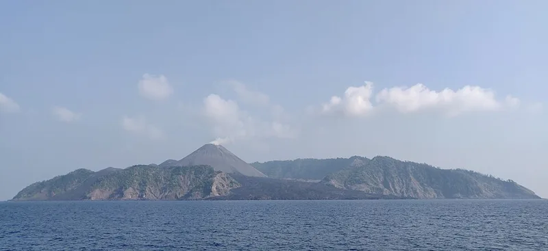
It is the only confirmed active volcano in the Indian subcontinent.
Asked in SSC CGL 2016
Practice (1)
Q20At Barren Island, the only active volcano in India is situated in
Show answer
Correct answer: B — Nicobar Islands
Answer: (B)
The correct option is (B).